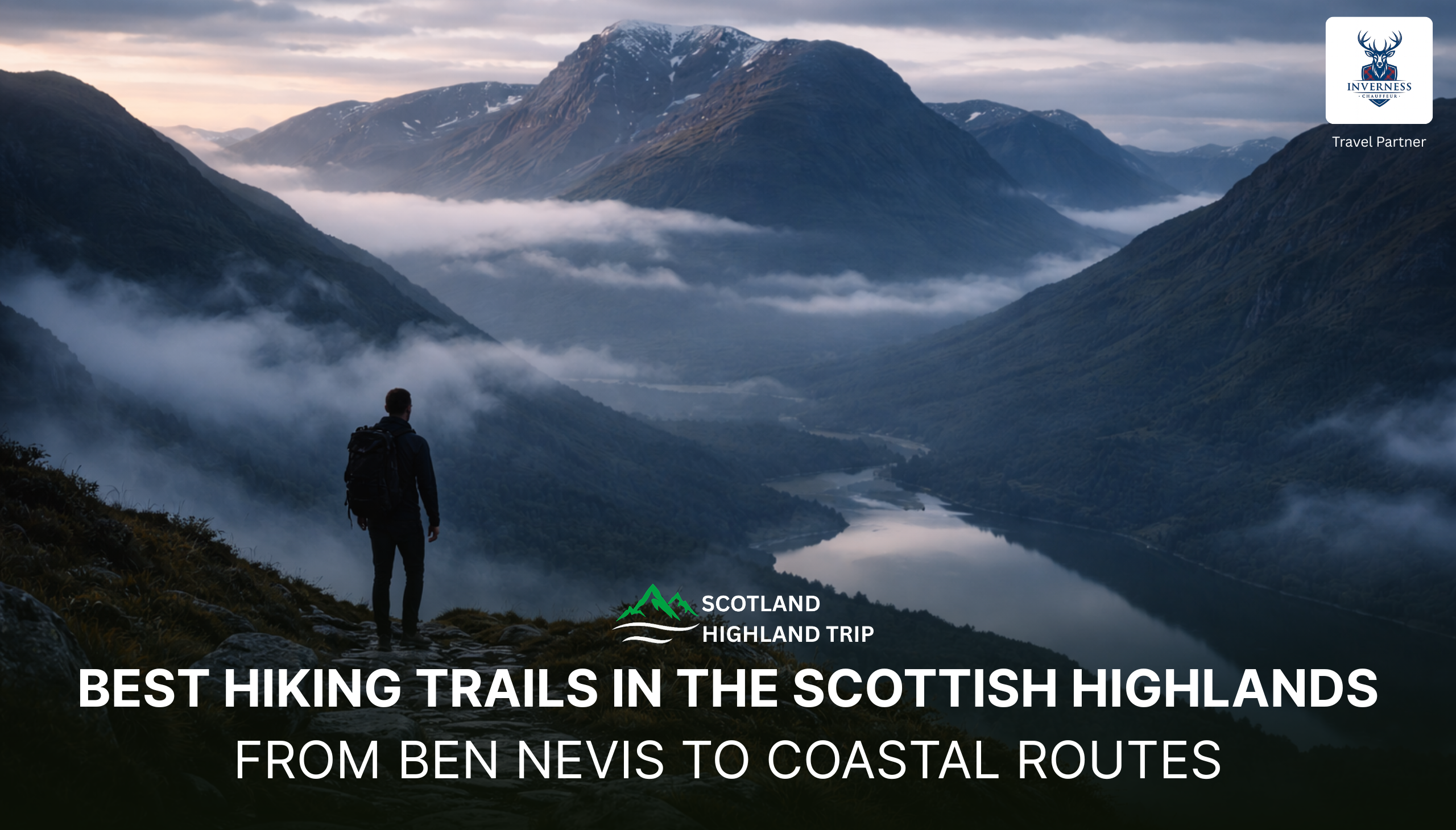
The Scottish Highlands conjure images of cloud‑cloaked peaks, mirror‑like lochs and coastal cliffs where the roar of the Atlantic mingles with calls of seabirds. This rugged region stretches roughly from the “Great Glen” fault line between Fort William and Inverness to the northern tip of Britain, embracing ancient glens, moorlands and islands. Walking here is not just exercise; it’s an immersion into Scotland’s folklore, geology and weather. The Highlands are also home to Britain’s highest mountain, Ben Nevis (1,345 m), and a host of classic long‑distance trails like the West Highland Way and Great Glen Way.
This guide covers everything and aims to be your one‑stop resource for the best hiking trails in the Scottish Highlands, combining popular peaks with lesser‑known coastal and circular walks. Whether you’re an experienced Munro‑bagger seeking a multi‑day expedition or a beginner looking for a scenic day hike, you’ll find practical advice, distances, start points and tips. Throughout, I’ll use the terms “Munro” (mountains over 3,000 ft), “scramble” for routes requiring hands‑on climbing, and “long‑distance trail” for multi‑day walks.
Pro tip: Always check the Mountain Weather Information Service (MWIS) forecast before setting out, carry an Ordnance Survey (OS) map and compass, and dress in layers, Highland weather can shift from sunshine to hail within minutes.
Jump to Section
Understanding the Highlands: geography, climate and seasons
Geography: The Highlands are split by the Great Glen, a long fault line running from Fort William in the south‑west to Inverness in the north‑east. West of the Great Glen lies a tangle of peaks, sea lochs and islands (including Skye and the Hebrides), while the east offers smoother, rounded mountains and ancient Caledonian pine forests. The Cairngorms form the UK’s highest plateau, while the north‑western Highlands boast distinctive sandstone summits like Suilven and Stac Pollaidh.
Weather: Expect four seasons in a day. Summers (May to September) offer long daylight hours, heather in bloom and generally stable conditions. However, midges (tiny biting insects) emerge in June–August, especially around lochs and forests. Autumn brings fiery colours and fewer crowds but shorter days. Winter sees snow on higher peaks, great for experienced mountaineers but risky for casual walkers. Spring (April to May) is ideal for avoiding midges and enjoying crisp, clear days.
Travel logistics: Major hubs include Inverness (gateway to the north), Fort William (base for Ben Nevis and West Highland Way), and Oban (ferry terminal to the Inner Hebrides). Train lines connect Glasgow to Fort William and to Mallaig (the route crosses the Glenfinnan Viaduct, made famous by the Harry Potter films). Local buses reach trailheads along Loch Lomond, Glencoe and Skye. Hiring a car provides flexibility but be prepared for single‑track roads.
Important Gear and Safety Steps to Consider
Packing the right kit can make the difference between a memorable adventure and a hazardous ordeal. Here’s a concise checklist:
- Navigation: OS Explorer maps, compass and a GPS device or navigation app (download offline maps in advance).
- Clothing: Waterproof jacket and trousers, insulating layers, hat and gloves—even in summer; robust hiking boots with good tread.
- Extras: Headtorch, whistle, first aid kit, emergency shelter, high‑energy snacks and at least 2 litres of water.
- Midge defence: Pack a head net and insect repellent from June to August.
- Transport: Many trails are point‑to‑point; plan return transport or consider arranging a shuttle/taxi.
Must‑know: Scottish access laws allow “right to roam,” but always follow the Scottish Outdoor Access Code, close gates, leave no trace and be respectful of private land and livestock.
Iconic peaks of the Highlands
This section covers the flagship mountain hikes that define the Highland experience. Distances and times are approximate and depend on conditions and fitness.
Ben Nevis (Fort William)
- Why go: As Britain’s highest mountain at 1,345 m, Ben Nevis draws hikers from around the world. The route described on Pitchup notes that it’s one of the country’s best‑known hiking trails. Views from the summit stretch across Lochaber and the Western Highlands.
- Route: Start at the Glen Nevis Visitor Centre near Fort William. The “Mountain Track” (also called the Tourist Track) climbs steadily past Lochan Meall an t‑Suidhe before zig‑zagging steeply beside the Red Burn. Allow 6–8 hours for the 17 km round trip.
- Difficulty: Moderate to strenuous; path is well‑made but steep and can be snow‑covered into June. In winter it’s a mountaineering route requiring crampons and ice axe.
- Pro tips: Begin early to avoid crowds; carry extra layers for the exposed summit; stop at the Ben Nevis Inn afterwards for well‑earned refreshments.
Ben Lomond (Loch Lomond & Trossachs National Park)
- Why go: At 974 m, Ben Lomond is a popular Munro offering panoramic views of Loch Lomond. Pitchup highlights that the route is a relatively easy day hike taking four to six hours.
- Route: From the car park in Rowardennan on the eastern shore of Loch Lomond, follow the clear path through forest and up the south shoulder to the summit. Descend via the Ptarmigan Ridge for a quieter loop.
- Difficulty: Moderate; suitable for fit beginners. The summit ridge is exposed so pack warm clothing.
- Pro tips: Start early to beat the crowds, especially in summer; consider a circular route combining the tourist path and Ptarmigan Ridge; reward yourself with a cruise on Loch Lomond afterwards.
Buachaille Etive Beag & Aonach Eagach (Glencoe)

- Why go: Glencoe’s jagged peaks provide some of the most dramatic scenery in the Highlands. Buachaille Etive Beag (958 m) is a twin‑peaked Munro that can be climbed in 5–6 hours, while the nearby Aonach Eagach Ridge is one of Scotland’s most thrilling scrambles, requiring hands‑on climbing and a head for heights.
- Route: The Buachaille trail starts at the Lagangarbh lay‑by on the A82 and ascends via a good path to a col between the two summits (Stob Coire Raineach and Stob Dubh). For Aonach Eagach, park at the Devil’s Staircase and traverse eastwards along a narrow ridge to the Pap of Glencoe.
- Difficulty: Buachaille Etive Beag is moderate; Aonach Eagach is challenging and includes exposed scrambling sections, only attempt in good conditions.
- Pro tips: Carry a map and know how to navigate; avoid Aonach Eagach in high winds; check bus times if starting and finishing in different places.
Stac Pollaidh (Assynt)
- Why go: Stac Pollaidh is a distinctive sandstone “stack” rising above Loch Lurgainn. Lonely Planet notes that hikers can reach the summit and return in less than three hours and enjoy incredible views of moody mountain peaks and silvery lochs.
- Route: From the car park on the north shore of Loch Lurgainn (30 minutes north of Ullapool), follow the clear path up through shrubland and then around to the rocky crest. The true summit requires a scramble; most walkers stop at the eastern summit cairn.
- Difficulty: Short but steep; basic scrambling skills needed for the final section.
- Pro tips: Combine with a visit to nearby Achiltibuie for fresh seafood; avoid in wet weather when the path becomes slippery.
Meall Fuar‑mhonaidh (Loch Ness)
- Why go: This rounded 699 m hill is the highest summit around Loch Ness. Pitchup notes that the 5.5‑mile round trip takes about three hours and offers views over the entire length of the loch.
- Route: Park in the small car park off the B852 near the village of Bunloit, then follow signposts through woodland and open moor to the summit.
- Difficulty: Easy to moderate; well‑marked path but boggy in places.
- Pro tips: Pack a picnic to enjoy on the summit; combine with a visit to Urquhart Castle or a cruise on Loch Ness; keep an eye out for the elusive Nessie!
Multi‑day trails: immerse yourself in the Highlands
Multi‑day walks allow you to experience the Highlands’ shifting landscapes and remote communities. These treks usually follow waymarked trails and provide accommodation options ranging from campsites and bothies to hostels and B&Bs.
West Highland Way

- Length: 96 miles (154 km)
- Duration: 5–8 days depending on pace
- Start/finish: Milngavie (Glasgow suburbs) → Fort William
- Highlights: Loch Lomond shoreline, Rannoch Moor, views of Buachaille Etive Mor, arrival at the foot of Ben Nevis.
- Best for: First‑time long‑distance walkers; well‑serviced path with plenty of accommodation and resupply points. Lonely Planet notes you can also tackle shorter sections and use buses or trains to return.
- Pro tips: Train your feet beforehand; carry midge nets; book accommodation early in peak season; treat yourself to a night at Bridge of Orchy Hotel or Kingshouse Hotel along the way.
Great Glen Way
- Length: 79 miles (127 km)
- Duration: 5–7 days
- Start/finish: Fort William → Inverness (following the Great Glen fault line)
- Highlights: Caledonian Canal towpaths, Loch Lochy, Loch Ness, views of Urquhart Castle, forests of Glen Affric.
- Best for: Walkers who enjoy a mix of canal paths and forest tracks; those seeking a gentler alternative to the West Highland Way.
- Pro tips: Take a detour to climb Meall Fuar‑mhonaidh for elevated views of Loch Ness; plan a night in Drumnadrochit to visit the Loch Ness Centre.
Cape Wrath Trail
- Length: 200+ miles (300+ km)
- Duration: 2–3 weeks
- Start/finish: Fort William → Cape Wrath lighthouse at the far north‑west tip of mainland Britain
- Highlights: Wild moorlands of Knoydart, remote bothies, crossings of rivers without bridges, finishing at the windswept Cape Wrath lighthouse.
- Best for: Experienced backpackers comfortable with self‑navigation, river crossings and remote conditions; the trail is unmarked and requires careful planning.
- Pro tips: Allow rest days in Kinlochbervie or Ullapool; arrange ferry across Loch Nevis; carry a PLB (personal locator beacon).
Hebridean Way
- Length: 252 km (155 miles)
- Duration: 10–12 days
- Start/finish: Vatersay (south of Barra) → Stornoway (Isle of Lewis)
- Highlights: Wildflower meadows on Barra, causeways linking islands, white‑sand beaches and turquoise waters, wildlife including seals and golden eagles.
- Best for: Those seeking a blend of coastal walking and island culture; hikers who enjoy mixed terrain and ferry crossings.
- Pro tips: Walk south to north with prevailing winds at your back; plan rest days to explore Harris beaches and Callanish Standing Stones; book ferries in advance.
Scenic day hikes and hidden gems
Not everyone has time for a week‑long trek. The Highlands are dotted with rewarding day hikes and short circuits that showcase the region’s diversity.
Lost Valley (Glencoe)
This short hike featured in the We12Travel blog leads to a hidden valley above Glencoe. The trail climbs for about an hour before revealing a secluded glen with panoramic views.
Duration: 2.5–3 hours. Distance: 4 km. Expect some scrambling and slippery sections. Start from the Three Sisters car park on the A82.
Glenfinnan Viaduct Trail
Fans of Harry Potter will recognise the Glenfinnan Viaduct. This easy 45‑minute loop offers views of the viaduct and Loch Shiel. Park at the Glenfinnan Visitor Centre and follow the signs to the viewpoint. Consider timing your visit to coincide with the Jacobite steam train crossing.
Glen Affric Circuit
For a quieter alternative to the Loch Ness crowds, Lonely Planet recommends the Loch Affric circuit (19 km, 4 to 6 hours). Starting at the Dog Falls car park near Cannich, the trail loops around the loch through ancient Caledonian pine forest with views of snow‑topped peaks. The route is well‑marked and suitable for most walkers.
The Quiraing (Isle of Skye)

Skye’s Trotternish Ridge features some of Scotland’s most iconic landscapes. Lonely Planet lists the Quiraing as “best for legendary landscapes” with an easy 4.5‑mile (7.2 km) circuit taking 2 to 3 hours. Start from the car park on the B855 above Staffin; the loop passes the Needle, Table and Prison rock formations. Beware of mist and high winds.
Coastal delights: Fife and Moray coast trails
While technically outside the Highlands, two coastal routes deserve mention for travellers exploring the wider region:
- Fife Coastal Path: Running 187 km from Kincardine to Newburgh, this long‑distance route passes fishing villages like Pittenweem, Anstruther and Elie, as well as the university town of St Andrews. It’s easily broken into day sections and links with train stations and bus routes.
- Moray Coast Trail: A 72 km route between Forres and Cullen, featuring sandy bays, dolphin‑spotting at Chanonry Point, and colourful harbour towns like Findhorn and Portsoy. Combine sections with whisky distillery tours along the Malt Whisky Trail.
Beginner‑friendly & circular walks
- Glencoe Lochan: An easy 1.5 km loop around a picturesque lochan (small lake) near Glencoe village; ideal for families and dog walkers. Picnic tables and parking available.
- Steall Falls & Nevis Gorge: A 4 km out‑and‑back walk starting from the Glen Nevis car park. The path passes through a dramatic gorge to Scotland’s second‑highest waterfall. Suitable for beginners but includes a wire‑rope bridge to the base of the falls, exciting but optional.
- Loch an Eilein (Cairngorms): A 7 km circuit around a tranquil loch with a ruined island castle; mostly level and good for all abilities. Start at the Rothiemurchus parking area near Aviemore.
- Ben A’an (Trossachs): A “mini‑mountain” rising to 454 m, Ben A’an offers a mountain experience in a half‑day. The well‑maintained path climbs steadily to a rocky summit with views of Loch Katrine and Ben Venue. Allow 2–3 hours.
Planning your hike: seasonal advice and practical tips
Best months to hike: The most popular months are May to September when days are long and temperatures mild. July and August can be wet and midge‑infested; May and early June offer fresh spring greenery and fewer midges. October brings beautiful autumn colours but shorter daylight; winter (November to March) is best left to experienced hikers with winter skills.
Daylight hours: In mid‑June, the Highlands enjoy nearly 17 hours of daylight, perfect for long hikes. In December, daylight shrinks to six hours, limiting walking options.
Transport & logistics: Many trails start and finish in different locations. Use public transport (trains, buses, ferries) to avoid back‑tracking; pre‑book taxis in rural areas; check ferry timetables for island routes. Scotland’s rural roads are often single track with passing places, drive with care.
Accommodation: Options include campsites, hostels, bothies (basic shelters), B&Bs and hotels. Bothies are free but offer no facilities; bring a sleeping bag, mat and stove. Wild camping is legal under the Scottish Outdoor Access Code, but leave no trace and respect local restrictions (e.g., by Loch Lomond during summer).
Wildlife & insects: Highland walks offer chances to see red deer, golden eagles, otters and seals. Carry binoculars and respect distances. Midges are worst at dawn and dusk near still water; wear a head net and use DEET‑based repellent.
Frequently asked questions
Where should I go hiking in the Scottish Highlands?
The Highlands offer endless options. For first‑timers, start with the West Highland Way or Ben Lomond for accessible yet rewarding routes. For adventure seekers, tackle the Aonach Eagach Ridge or Cape Wrath Trail. To sample island scenery, hike the Quiraing or sections of the Hebridean Way. And for forested tranquillity, explore Glen Affric.
What is the best month to hike in Scotland?
The ideal months are May and June, long days, mild temperatures and relatively few midges. Early September is also good for settled weather and quieter trails. July and August can be wet and crowded, while winter hikes require specialised skills and gear.
What is the prettiest village in the Scottish Highlands?
Beauty is subjective, but many hikers fall for Portree on the Isle of Skye with its colourful harbour and backdrop of the Cuillin Mountains; Tobermory on the Isle of Mull with its cheerful waterfront houses; Plockton near Kyle of Lochalsh for palm trees and sea views; and Shieldaig on the west coast with views of Torridon peaks. These villages make excellent bases for nearby hikes.
What is the most beautiful mountain in Scotland?
Choices vary, but contenders include Suilven, a whaleback ridge rising from the wilds of Assynt; An Teallach, a complex Torridonian massif with razor‑edged ridges; Buachaille Etive Mor at the entrance to Glencoe; and the Cuillin Ridge on Skye. Each offers unique challenges and stunning vistas, choose based on your experience and appetite for scrambling.
How can I find maps of the best hiking trails?
The Ordnance Survey (OS) Explorer series (1:25,000) covers the Highlands in detail and is available as paper maps or via the OS Maps app. Hiking blogs often embed interactive maps, and the WalkHighlands website provides free GPX downloads and route descriptions. For smartphone use, download offline mapping apps and GPX tracks before heading out.
What are the best day hikes in the Scottish Highlands?
Top day hikes include Ben Lomond, Stac Pollaidh, Lost Valley, The Quiraing, Sgùrr Eilein (Sutherland), Suilven (challenging but doable in a day), and the Glenfinnan Viaduct Trail. For something easier, try Glen Affric circuit, Loch an Eilein, or Ben A’an.
Are there hiking trails suitable for beginners?
Yes. Glencoe Lochan, Steall Falls, Loch an Eilein, Cairn Gorm ski centre’s Ptarmigan Ridge (via funicular) and Meall Fuar‑mhonaidh offer manageable distances and clear paths. Start small, build fitness and gradually tackle longer routes like the West Highland Way.
What are the best multi‑day hikes in Scotland?
Besides the West Highland Way, notable multi‑day hikes include the Great Glen Way, Cape Wrath Trail, Hebridean Way and Skye Trail (a challenging unofficial route crossing the island). On the east coast, the Cateran Trail and Speyside Way offer gentler gradients and pass through whisky country.
Are there circular walks in the Highlands?
Yes. Glen Affric circuit, Loch an Eilein loop, Glencoe Lochan, Ben A’an and the Quiraing circuit all return to their starting point. Circular routes are convenient when using your own car and minimise transport logistics.
Where and what is West Highland Way.
The West Highland Way is a 96‑mile trail from Milngavie near Glasgow to Fort William. It typically takes seven days and passes through Loch Lomond & The Trossachs National Park, Rannoch Moor and Glencoe before finishing at the foot of Ben Nevis. It’s Scotland’s most popular long‑distance walk, with well‑marked paths and plenty of accommodation. Many hikers use luggage transfer services to lighten their load.
After reading through these hikes and tips, you may be itching to lace up your boots. Ready to explore? Plan your Highland adventure today, book a local guide, reserve accommodation along the West Highland Way or simply mark a date on your calendar for your first Munro. If you need help organising a bespoke itinerary, our team offers personalised planning services. Get in touch and start your Highland story.

Emma is a solo traveler and freelance travel writer from New Zealand who spent three weeks exploring the Scottish Highlands. With a deep appreciation for history and landscapes, she booked a series of day tours and a private chauffeur journey with Scotland Highland Trip. From Loch Ness to the Cairngorms, she documented her experience through vivid blog posts and drone footage.

 2")


